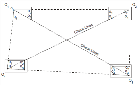
Traversing
The method of radials or intersection (from a base line O1O2) could be used preferably for little level surveys. Therefore, plane table could also be used for traversing surveys of wide and huge areas same to chain and compass surveys, for closed and open both traversing.
Survey lines O1 - O2 - O3 could be run among stations that are already predecided through other methods. The topographical details are fixed through plane table traversing. The step-by-step procedure could be elaborates as follows:
(a) Traverse stations O1, O2 . . . , O3 are predecided on ground.
(b) Set and level a table at O1 and mark o1 on sheet accurately above O1 using U frame. Centering the alidade at O1 and other traverse stations O2, O3 . . . etc. that could be sighted from O1, are observed and rays O1 O2 , O1 O3, O1 O4, . . . , etc. are drawn.
For topographical details stations A, B, C . . . etc. is sighted and rays drawn that was show in the Figure 4.
(c) The table is then shifted to further station O2, fixed levelled and oriented. Position of station O2 is marked on sheet. Radial rays O2 O1, O2 O3, O2 O4 are then drawn along with alidade centered on O2. The intersection of rays O1 O3 and O2 O3 will provide the location of station O3 on sheet and so on.
The ground characteristic A, B, C, etc. could be same located on map through drawing rays from station O2. Details could also be situated through method of radials.
(d) The procedure is continued till completion of survey.

Figure : Traversing
(e) Accuracy is checked through sighting station O1, O2 . . . etc. from more than two stations so that three radial lines merge at referred station. Therefore, if a particular traverse point is not observable from more than two traverse stations, some well described object on area could be temporarily selected as instrument station for checking.