Radiation
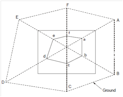
This is most direct and easy method of recording observations during plane table surveying. An instrument station O is selected and instrument is set and oriented at this station. The point of interest, representing significant ground features, natural or created, is situated on map plan through drawing a ray from the plane table station to that point along with the help of alidade and plotting to scale the measured distance as display in Figure.

Figure : Radial Lines Method
Small land areas can be surveyed from a single instrument station on one table setting at a predetermined and located position. The instrument station is chosen such in which entire area is visible and approachable from this position for distance sighting and measuring. The instrument station designated O1 is plotted on drawing sheet exactly oriented and levelled at ground station O1 with the help of U frame as depicted in Figure 2(b). The several survey target points A, B, C etc. are sighted through centering the alidade on O1 and rays drawn along its edge. The distances O1A, O1 B etc. could be measured through chain/tape and plotted as O1 a, O1 b, on the sheet. The N-line is marked at top of the sheet along with the help of compass.
This way the traverse abcdef could be plotted. Accuracy could be checked through measuring ground distances AB, BC etc. and comparing along with map distances ab, bc and etc.