Marking the Stations:
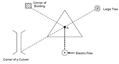
The first step in chain survey is to decide and locate stations so that they are distinctly visible and are quasi-permanently fixed during the surveying process. The position of stations are located on map such that the base survey line and other main survey lines are so aligned that the positions of all salient ground features, either natural or man made, can be located and measured. The position of stations is fixed along with reference to some permanent ground features so in which they can be unambiguously and accurately located on ground at anytime in future also, if the station pegs are removed/misplaced (Figure).

Figure: Station Location
It can be noted that the distance of station A must be measured from atleast three permanent ground features, e.g. electric pole, large tree, building or culvert and etc. existing within the vicinity of the station. The location sketch of the station as given in Figure 6 is very helpful in retracing the station position in future.
The survey stations are marked temporarily on ground through fixing the ranging rod at their location. A wooden peg is driven within the ground such in which it is projecting at least 40 mm above the ground to give some permanency. A cross could be painted or etched on ground if a few hard surfaces like road, pavement or rock is encountered at station location. For permanent marking, the concrete or stone block can be embedded in ground.
Intermediate stations along with the main survey lines of large lengths are generally located by the process of ranging.