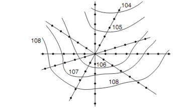
Radial Line Method
Several radial lines are taken from a point in the area in this method. The direction of each line is noted down. Points are marked and levels determined on these lines at selected distances. Ideally this method is suited for hilly areas. theodolite with tacheometry facility is used common, in this survey.

For the purpose of interpolating contour points between the two points any one of method may be used from following:
(a) Estimation
(b) Arithmetic calculation
(c) Mechanical or graphical method.
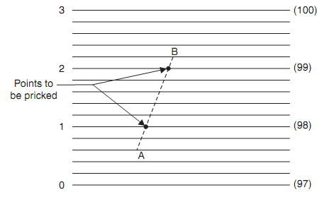
The mechanical or graphical method of interpolation consists in linearly interpolating contour points by using tracing sheet:
At regular interval on a tracing sheet several parallel lines are drawn. For easy counting every 10th or 5th line is made darker. If RL of A is 97.4 and that of B is 99.2 m. suppose the most bottom dark line represents. 97 m RL and every parallel line are at the 0.2 m intervals. Then hold the second parallel line on A point. Rotate the tracing sheet so that 100.2 the parallel line passes through B point. Then the intersection of dark lines on AB represents the points on 98 m and 99 m contours as shown in figure. The contour points along any line connecting two neighbouring points may be obtained and the points pricked, similarly. This method maintains the accuracy of arithmetic calculations at the same time it is fast.

After locating contour points on a contour line smooth contour lines are drawn connecting corresponding points. For drawing smooth lines French curves may be used. A surveyor on the ground should not lose the sight of the characteristic feature. For easy readibility every fifth contour line is made thicker. On every contour line its elevation is written. it is written at the ends also If the map size is large.