Characteristics of Contour Lines
Features of contour lines are helpful in plotting and interpretation of several features in the map. These characteristics are as given below:
(a) Contour line is a line joining points of similar elevation; hence all points of contour lines have similar elevation. The elevation of a contour is written close to the contour.
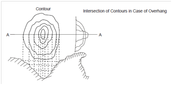
(b) Two contour lines of several elevations cannot intersect every other except in case of an overhanging cliff or a cave (Figure ).

Figure : Section of Ground Surface at A-A
(c) In that case of vertical cliff contour lines of several elevations could join to form one single line.
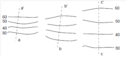
(d) Horizontal equivalent of contours denotes the topography of the area. The uniformly spaced contour lines imply a uniform slope, although straight and equally spaced contour line denotes a plane surface. Contour lines closed together denote steep slope, although a gentle slope is indicated while contour lines are far apart.

Figure : Topography of Area Represented by Variation of Horizontal Equivalent
(e) A contour line cannot end anywhere and must close upon itself, through not necessarily inside the limits of the map.
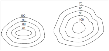
(f) A set of close contours along with higher figures outside and lower figures inside denotes a depression or lake, although a set of close contours along with higher figures within and lower figures outside indicate a hillock.

(a) Depression (b) Hillock
Figure : Set of Contour Showing Depression and Hillock
(g) Contour lines cross a water shed (or ridge line) and a valley line at right angles. In that case of ridge line, they form curves of U-shape across it along with concave side of the curve towards higher ground, while in case of valley line, they form sharp curves of V-shape across it within convex side of curve towards higher ground.