Define bank volume to be stockpiled and used for backfill, Civil Engineering

Assignment Help:

An earthwork contract was awarded to excavate and backfill the foundation of a proposed 50-ft by 50-ft office building.  The existing grade elevation is 437.5-ft while the sub-base for the below grade basement is 432.5-ft.  The concrete contractor requires a 3-ft perimeter walkway in order to place the concrete formwork. 

Soil conditions are classified as OSHA Type B soils which require 1H:1V side slopes. The bank volume (yd3) to be stockpiled and used for backfill is most nearly:

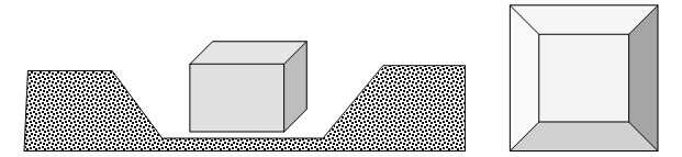
Solution:The foundation excavation can be described as an inverted truncated pyramid.  Compute the earthwork volume using the buildings dimensions and add a 3-ft perimeter walkway around the building for the workers erecting the concrete formwork. Equation for the volume of a truncated pyramid:

2424_Define bank volume to be stockpiled and used for backfill.png

Volume = V1 = h/3 (A1 + A2 + √(A1 x A2))

Compute depth of foundation = h = 437.5-ft - 432.5-ft = 5.0-ft

A1 = Area of the base of truncated pyramid = (50 + 3 + 3) (50 + 3 + 3) = 3,136-ft2

A2 = Area of the top of truncated pyramid = (50 + 3 + 3 + 5 + 5) (50 + 3 + 3 + 5 + 5) = 4,356-ft2

V1 = 5/3 (3,136 + 4,356 + (√(3,136 x 4,356)

V1 = 18,647-ft3= 690-yd3

Compute the volume of the basement and subtract this from the total excavation to determine the volume of backfill material.

Building Volume = 50'  x 50'  x 5' =  12,500-ft3  =   463yd3

Backfill stockpile required = 690-yd3 - 463-yd3 = 227-yd3


Related Discussions:- Define bank volume to be stockpiled and used for backfill

Deep foundation, At what places deep foundation are made?

At what places deep foundation are made?

Explain what is stationing - transportation, Explain what is Stationing - T...

Explain what is Stationing - Transportation 1) Stationing concept is used along horizontal alignments for referencing purpose 2) 1 station = 100 feet 3) How do you repres

Survey, 3-d figure of line ranger

3-d figure of line ranger

Surveying, shrinkage factor in plans

shrinkage factor in plans

Water-bound macadam road construction for unpaved roads, how can I come up ...

how can I come up with the research on the water bound macadam road construction

Timber, seasoning of timber

seasoning of timber

Explain remote sensing technique, Q. Explain Remote sensing technique? ...

Q. Explain Remote sensing technique? Remote sensing is a science or an art of obtaining the information about an object, area or a phenomenon through analysis of data acquired

Write Your Message!

Captcha
Free Assignment Quote

Assured A++ Grade

Get guaranteed satisfaction & time on delivery in every assignment order you paid with us! We ensure premium quality solution document along with free turntin report!

All rights reserved! Copyrights ©2019-2020 ExpertsMind IT Educational Pvt Ltd