Reference no: EM132854825
Unit 7 Surveying, Measuring and Setting-Out - Pearson Higher Nationals in Construction and the Built Environment
Assignment - Control Stations and Topographic Surveying
Assignment Title - Measurement & Estimating Techniques
Learning Outcome 1: Undertake a survey to establish a station network for horizontal and vertical control.
Learning Outcome 2: Explain the process of undertaking a topographic survey.
Learning Outcome 3: Apply industry standard techniques in the production, transferring and staking out of co-ordinates of multiple construction elements.
Learning Outcome 4: Prepare a report on the causes of errors and techniques to improve accuracy, including the use of digital data.
Assignment Brief
Scenario:
You are employed by a local surveying company and have been approached by Sri Lanka land development corporation for a full topographic survey of a local plot of land. The topographic survey is required for the initial and detailed design process. Part of the requirement is to set a control network of stations that can be used for future surveys and to aid in the setting out once construction commences.
The Subodhi Retreat Centre is located along the Bolgoda Lake in Piliyandala, in the Western Province of Sri Lanka. Due to the increase in the number of patrons visiting the premises for meditation and other activities the management has decided to construct a new residential centre in the rear end of the land. This will be a two-story building inclusive of a water garden where the patrons can relax. A Google image of the location is given in Figure 1.
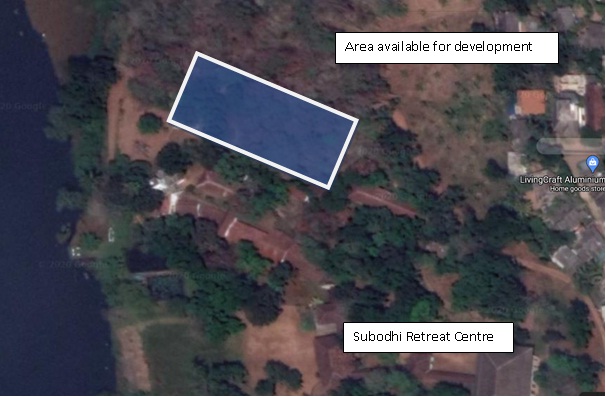
Figure 1
Task
Assume your group is appointed as the survey team to construct the survey for the project of designing the new residential centre. Follow the steps provided below and produce required outputs.
• Explain briefly how a new location coordinate can be established from the national surveying grid.
• Run a closed traverse using a digital theodolite around the existing management building to grab the existing details of the area. (Note: Your traverse should have at least five traverse legs and need to provide all the necessary calculations including the coordinate corrections and coordinate sheet).
• Run a level line to obtain heights of control points of traverse and produce a level sheet indicate the heights.
• Produce a topographic map using the details collected according to a suitable scale.
• Review the suitability of the land area surveyed for the proposed construction based on the topographic data.
• If it decided to rehabilitate the internal roads within the premises. Produce a longitudinal section (LS) of at least 200m having staff stations at 10m intervals. You should select suitable scales for horizontal and vertical scales and your final drawing should have the existing longitudinal profile and the proposed design profile for the road.
• Produce cross sections (CS) for the same 200m length on the road section in 20m intervals according to a suitable scale indicating the existing cross section profile and proposed design cross section profile.
• Provide a cut and fill calculation if it is assumed that a constant gradient is to be maintained for a new road design.
• Draw a plan view of proposed building using Auto CAD.
• Calculate necessary coordinate data required to set out the above proposed building and road centre line and present them in a tabular form. Perform a setting out of the building using appropriate surveying instruments.
• Explain the types of errors that may arise during these survey works (Traverse survey, topographic survey, levelling and setting out) and evaluate methods to minimize those errors and increase the accuracy of the work.
• Prepare a project report demonstrating your work including photographs of field work done, calculations (if any), and drawings.
Note: Each drawing should be submitted individually, and the final project report will be done as a group work. An individual evaluation will be done for each student during the field work to evaluate the skills of students on handling the surveying instruments.
Attachment:- Surveying Assignment.rar
|
Describe nurse role and responsibility as health educator
: What strategies, besides the use of learning styles, can a nurse educator consider when developing tailored individual care plans
|
|
How the ehr supports technological needs
: Applicability to the health care practice setting and workflow support. How the EHR supports technological needs (cloud-based vs. client-server)
|
|
Statements about the distribution of the scores
: Based on this Information, complete the following statements about the distribution of the scores on the writing section for the recent year.
|
|
Why is there increasing emphasis on nutrition
: Why is there increasing emphasis on nutrition and exercise for middle aged and aging families? Why is it more significant than 30 years ago
|
|
Unit 7 Surveying, Measuring and Setting-Out Assignment
: Unit 7 Surveying, Measuring and Setting-Out Assignment Help and Solution, Pearson Higher Nationals in Construction and the Built Environment - Assessment
|
|
What type of follow-up would you schedule for the patient
: What type of follow-up would you schedule for this patient and why? What further investigation/work-up would a provider consider (labs, scans, referrals)?
|
|
Depict the solar deity Ra-Horakhty
: What two forms were used to depict the solar deity Ra-Horakhty? What is the significance and meaning behind the battles scenes so often depicted on temples?
|
|
How discrimination and privacy are managed
: How discrimination and privacy, confidentiality and disclosure are managed. Roles and responsibilities of clients, family members, friends and support workers
|
|
Find the equilibrium for this 2-round game
: Find the equilibrium for this 2-round game. What is the sale price of the home? Which player gets the larger share of M?
|