Reference no: EM132403684 , Length: 5 pages
University of the Philippines
College of Engineering
Energy Engineering ProgramLaboratory Exercise on
HYDROPOWER SITE ASSESSMENT
Objectives:
1. To enable students identify potential sites for hydropower development and determine its characteristics
2. To be able to compute for the design of the potential site based on its resource characteristics
Procedure:
1. Draw the boundary of the watershed. You can do this by drawing a line starting from the dam and connect the ridges, mounds or hills surrounding the watershed. The line must return to the other side of the dam. Make sure that the streams and creeks flowing into the targeted dam site do not cross the watershed boundary.
2. Draw the cross section of the dam weir/reservoir and estimate the total dam area at 900m maximum elevation. Use trapezoidal rule to compute for the area of each section and add them. Draw the cross-sectional diagram similar to the figure below with the necessary dimensions.

3. Determine the inundated area of the reservoir when the target water elevation is 900m. You can do this by following the 900m contour line starting from the dam site (intersection of the 900m contour line and the dam cross section) within the watershed. The inundated area must be inside the watershed boundary. Estimate the inundated area (in hectares) by drawing and counting 100m grids within the elevation. One grid is one hectare (1 ha.) each.
4. Determine the reservoir volume if it is filled up to 900m elevation. To do this, create small horizontal grids of 100m each within the inundated area. Determine the height from water surface to bottom ground elevation.
5. Determine the utilizable head if you intend to build the intake at 820m elevation which is to be connected by a penstock to a turbine located at 20m below. Measure total power available by the equation
E = ρwaterghutilVreservoir
where:
g: acceleration due to gravity (m/s2) = 9.81m/s
hutil: effective head of water (m)
Vreservoir: the volume of the reservoir (m3).
Note that the 820m is the minimum water elevation. Below this value, the discharge will be (zero) 0.
Requirements:
1. Write a report showing the following:
a. The shape, size and area of the watershed (including drawing/s)
b. The shape, size, area and volume of the reservoir filled at 900m maximum elevation (including drawing/s)
c. Total power generated for the design parameters given.
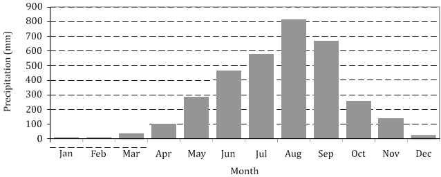
2. Shown in the figure below is the rainfall distribution at the nearest weather station in Baguio City. If the rainfall in this region is about 3413mm per year, determine the total water available for the watershed area if the average evapotranspiration over the reservoir is 5mm/day.
3. Compute for the total power available for the year P = ηρwatergqwaterHutil. where:
h: hydraulic efficiency of turbine expressed as fraction; assume 90% efficiency.
For flow rate q=vintake hutil, it can be based on the opening area A of the intake with diameter d=1m. vintake is then determined by:
vintake = g√2hutil
Considering the discharge to the penstock and the evapotranspiration, how much water is left in the reservoir at the driest period?
Based on the table below, how would much you categorize the potential power that can be generated from this site?